 VANCOUVER, BC/CANADA – JULY 30: People enjoying the day at the Kitsilano beach in Vancouver, Canada on July 30, 2015. Kitsilano Beach is one of the most popular beaches in Vancouver. / Shutterstock
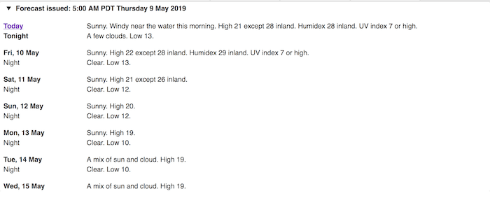
The Metro �鶹��ýӳ��weather forecast calls for inland temperatures to reach a sizzling 28°C on Thursday and Friday this week. However, things may start to cool off in the days to follow.
�鶹��ýӳ�� spoke to Doug Lundquist, Meteorologist, Environment Canada, who explained what the Lower Mainland had to look forward to in the coming weeks.
"The average temperatures for this time of year are around 16°C. So, we've seen some unseasonably warm temperatures this past week, and will continue to see this weather pattern through the week," he explained.
"With this in mind, we usually see a wetter pattern develop toward the middle of May and through until about mid-June. And, with more precipitation in forecast, we predict that the soaring temperatures will drop."
Lundquist notes, however, that this cooler weather pattern won't feel chilly, and it may still produce above average temperatures.
"While temperatures are expected to drop a couple of degrees next week they may still be above average. Currently, we have daily highs of 22°C and up to 28°C inland, so even if these temperatures drop to 17°C or 18°C next week, they'll still be a degree or two above average."

Environment Canada
 Environment Canada
Metro �鶹��ýӳ��Weather
On Wednesday, March 20, a jaw-dropping 48 weather records were broken across B.C. What’s more, some areas saw soaring highs of nearly 26°C.
For example, the Agassiz Area broke its old record of 21.7°C set in 1915 with a summery high of 25.8°C. Likewise, the Squamish Area broke its old record of 21°C set in 1999 with a toasty 25.9°C daily high.
Environment Canada has also stated that the presence of a weak El Niño will affect temperatures heading into summer. As such, the department expects that the province will see above average temperatures this summer.


