 Photo: @EdmundJ_in140 / Twitter
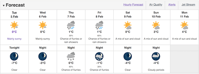
The �鶹��ýӳ��weather forecast calls for a frigid minus seven overnight on Tuesday, February 5, but the temperature is predicted to rise later in the week.
With that being said, the reprieve won't last into the next week, when the frigid weather is expected to return to the Lower Mainland.
�鶹��ýӳ�� spoke to Matt MacDonald, Meteorologist, Environment Canada, who explained why the region would see a return to the blistery temperatures.
"We are going to see another significant drop in temperatures next week as Arctic Air pushes downwards into the region," he demonstrated. "We will see cold air push down from the northern interior and make its way to the coast."
"With that in mind, what we are seeing isn't part of the polar vortex that is hitting central and eastern Canada - that is a different pressure system all together."
MacDonald confirmed that there is a high probability of snowfall this week, too. In fact, Thursday has a 30 per cent chance of flurries or rain showers during the day, while Thursday night has a 60 per cent chance of flurries.
Following this, Friday also has a 60 per cent chance of flurries or rain showers during the day. It will also have a thirty per cent chance of flurries in the evening as the weather dips down to minus one.
�鶹��ýӳ��Weather Forecast
 Photo: Environment Canada
While MacDonald noted that the cold weather would return next week, he was unable to speculate about the likelihood of snowfall.
"As always, precipitation is difficult to predict further out - it is much easier to identify a temperature system."


