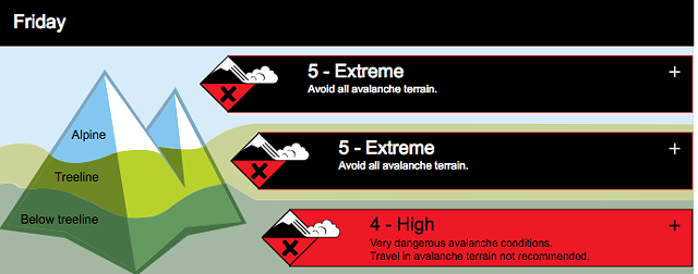
ŌĆ£Very large avalanches are almost certainŌĆØ on Friday, Jan. 3, warned Avalanche Canada in an uncommon extreme avalanche warning issued for the Sea-to-Sky mountains.
In a statement, the organization said it ŌĆ£rarely seesŌĆØ the danger rating rise to extreme, and, on its website, urged the public to avoid all avalanche terrain as ŌĆ£intense precipitation will form large storm slabs and add tremendous stress to an already wet snowpack.ŌĆØ
ŌĆ£We typically see extreme ratings about once or twice per year and thatŌĆÖs across all of Western Canada,ŌĆØ added Avalanche Canada forecaster Simon Horton in a follow-up call.
The extreme danger rating for Friday applies to the treeline and alpine areas in the backcountry, and lowers to ŌĆ£highŌĆØ through the weekend.
It went on to say that avalanches have the potential to run long distances and destroy mature timber. ItŌĆÖs the combination of ŌĆ£a very high probability of avalanches and the fact that the avalanches are expected to be very largeŌĆØ that has resulted in the rare extreme rating, Horton explained.
While the greatest risk was posed during the ŌĆ£peak intensityŌĆØ of Friday morningŌĆÖs storm, large natural avalanches are ŌĆ£likelyŌĆØ through the day and the rest of the weekend, Avalanche Canada said.
Approximately 40 centimetres of snow fell around Whistler between Thursday night and midday Friday, combining with freezing rain and strong southwesterly winds.
A weaker New YearŌĆÖs Day storm deposited about 40 cm of snow above a layer of surface hoar, which led to ŌĆ£reactive storm slabsŌĆØ in the past few days. Multiple weak layers are buried deeper in the snowpack, the forecast said, including a variable layer of surface hoar and crust from mid-December as well as ŌĆ£a deeper layer of sugary facets and crustŌĆØ from late-November.
"ItŌĆÖs been quite stormy for the last few weeks but the fall was relatively dry, so that set up a weak snowpack structure, so when there was little snow on the ground in November and early December, it formed a lot of weak snow, and since then, these past few weeks when itŌĆÖs been snowing harder, the bottom of the snowpack isnŌĆÖt able to support the weight of this new snow,ŌĆØ Horton noted. ŌĆ£WeŌĆÖve seen what we call ŌĆśpersistent slab avalanches,ŌĆÖ which are much thicker than what youŌĆÖd typically get just during a storm.ŌĆØ
A second intense storm is in the forecast for Friday evening, expected to bring another 30 to 50 cm of snow above 700-metre elevation by Saturday afternoon. Another storm is expected to bring 15 to 30 cm of snow on Sunday.
At Whistler Blackcomb, all upper alpine terrain remains closed. Both the Peak 2 Peak and the upper portion of the Blackcomb Gondola are also closed. At press time, all skiing and riding has been relegated to ŌĆ£restaurant-level and below,ŌĆØ said Marc Riddell, Vail ResortsŌĆÖ West Coast communications director.
Riddell advised the public to obey all signage and rope lines to stay safe. ŌĆ£TheyŌĆÖre there for a reason,ŌĆØ he said.
Avalanche mitigation will likely continue at Whistler Blackcomb on Friday and Saturday ŌĆ£before we make any decision as to whether or not weŌĆÖre going to open the alpine,ŌĆØ Riddell noted.
To read the full avalanche warning and forecast, visit .
╠²
Read the original article .


